This past week I measured DBH and calculated the height of the 21 trees on the lawn outside of Roger Bacon.
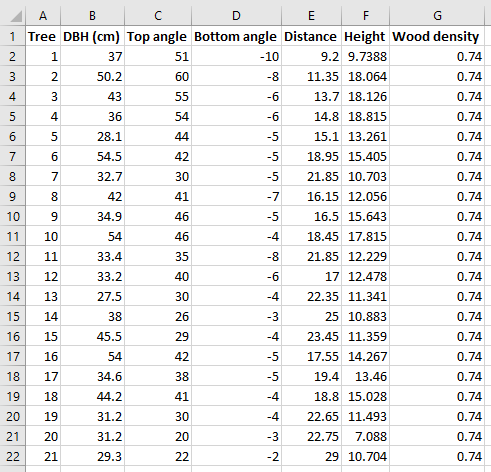
Top angle, bottom angle, and distance weer obtained with a clinometer and distance tape and were used to estimate the tree’s height (in meters). The trigonometric equation to find the height is expressed in excel as

The wood density is a species specific value. I am pretty sure that the trees are all red oaks, which have a wood density of 0.74 g/cm^3, but I should double check I have the correct species before I progress much further.
Usually when I start a project I like to have a very clear idea of what the end product will look like. This project is different–I’m remaining open to the possibilities of what the map might look like depending on what I am able to accomplish in iTree Eco and with raster data.
I talked with Dr. M today about the possibility of displaying the map as one with graduated size points for the trees outside of RB according to their carbon stock, and she had the idea of using model builder to create a raster layer (called kernal density rasters) of carbon stock in the trees. This could be illuminating as to how carbon stock is clustered in certain parts of a plot and then could be ran on larger tree surveys. I really like this idea and I think I will pursue it. In my opinion it would make more sense to calculate carbon stock manually in excel using allometric equations, upload it as a csv, and mess around with it in ArcMap (or maybe ArcGIS Pro? I’ll ask about this soon). I found a resource for calculating the carbon stock of urban trees using known values (https://serc.carleton.edu/eslabs/carbon/1b.html) given DBH and tree species (which has corresponding numeric values based on species wood density). These estimates do not factor in height, which means they are not super robust (and, like, I have tree heights already so I might as well use them!). I will keep looking for a good allometric equation to use for oak species in NY that factor as height, but will use the methods described in the link above if that does not work.
My next steps are to: research allometric equations, confirm tree species ID, calculate above-ground biomass and then use that to find carbon stock, upload this data to ArcMap (or Pro), make a graduated size map with points corresponding to carbon stock, and then investigate how to make a kernal density map using Model Builder. Exciting stuff!!

